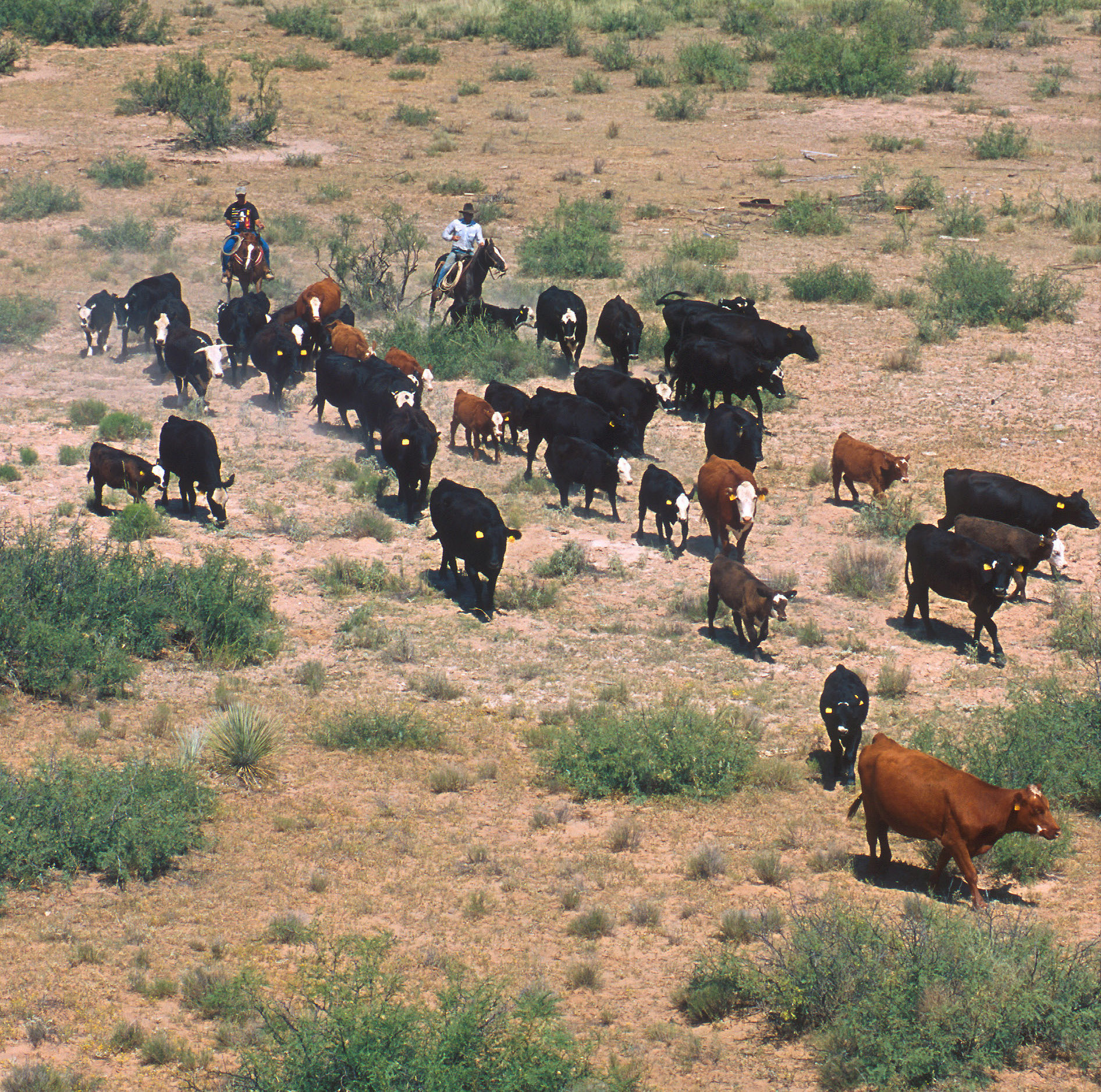
Cattle are still herded today as they were in Northumbria.
It’s still an open question what proportion of the population in Northumbria was Anglian and what Britonnic. There were probably pockets of each spread through a sparsely peopled landscape, although it seems likely that the Britonnic population was more inland and Anglian villages lined the coast and the riverways.
In Hope-Taylor’s excavation of Edwin’s royal palace at Ad Gefrin, in the lea of the Cheviot Hills and under the shadow of the Iron Age hillfort atop Yeavering Bell, he found traces of a huge enclosure for cattle and sheep. He interpreted this as the corral where the hill folk brought their render of livestock for the king when he and his household, on their itinerant progress through the kingdom, stopped at Ad Gefrin.
It’s likely that these pastoralists of the high country were of the same lineage as the first people to practice transhumance during the Neolithic. When Edwin’s golden hall stood at Ad Gefrin under the Hill of the Goats, the great circling ring of the hill fort would still have glowed pink, the colour of the quarried andesite from which it was made. Centuries of weathering have dimmed the shock of pink that once wreathed the hill. But Edwin saw it shining bright above his golden hall, a stronghold made by the ancestors of the people who now came down from the hills with their render of sheep and goats and cattle.
Although Bede presents the council as approving the change to the new religion, Edwin himself did not convert . After all, the old gods had been kind to him. He had overcome his persecutor, Æthelfrith. His mentor, Rædwald, had died, probably of natural causes, leaving him the most powerful king in Britain. He had cemented an alliance with the Christian kingdom of Kent through his new wife. Why rock the altar?
It was a close encounter with death that decided Edwin to change religion. A rival king sent a suicide assassin but one of Edwin’s men took the blow intended for the king. In the struggle, Edwin was still wounded by the poisoned dagger. At the time of the attack, Queen Æthelburh was in labour and gave birth to a daughter that night. Edwin swore that if the new god gave him victory over the rival king, then he would pay him back, by his own conversion and by allowing the baptism of his new daughter.
Edwin duly recovered and waged punitive war against his rival, returning with enough heads to conclude that the deal had been sealed. He would tie his future fortunes to the new god.
The question was what would happen should the new god’s favour not always lead to victory and glory. After all, if it was simply a matter of signing up to a new religion and all your wishes coming true there would only be one religion in the world.
The fragility of the new faith was exposed when, in one of the catastrophic reverses that was a fatal feature of kingship during this era, Edwin, at the height of his power, lost the Battle of Hatfield Chase and his life too.
His queen fled to Kent with their children. Her priest, Paulinus, who had baptised hundreds of converts, fled too, later becoming Bishop of Rochester.
The church that Edwin had converted to and fostered essentially collapsed.
After all, in the currency of power, death in battle was the great bankruptcy.
A substantial part of Bede’s Ecclesiastical History is taken up with the long process of Edwin’s conversion to Christianity and, as a result, we have the first character portrait of English literature. Bede portrays Edwin as cautious and capable, a king weighing up the relative advantages of remaining true to the gods of his fathers or accepting the new god. The single most famous scene in Bede tells of the council that Edwin summoned, gathering his warriors and also his existing priesthood, to debate the merits or otherwise of conversion.
Rather unexpectedly, according to Bede the most enthusiastic advocate for conversion was Coifi, Edwin’s pagan priest. As Bede had close contacts with the Northumbrian royal court, there’s no reason to think that he made this up. According to Coifi, he had done everything the gods required of him, making sacrifice, offering up prayers, doing all that was required and, in return, he was no better off than men who had ignored the gods.
While it might seem strange to us that a priest should advocate giving up his religion on such pragmatic grounds, it does fit with the basic point of polytheistic religion. The world these religions dealt with was uncertain: disease, storms, famine and death stalked the world, personified by the powers of sky and earth. The gods, as those personifications, were as fickle as their earthly powers. The key purpose of religion was to change the odds in your favour by appeasing and placating inscrutable gods.
But Coifi says up front that he’d done all that to no end. He’d performed the rituals, made the sacrifices, done all that the gods asked of him, and it had not produced results. So rather like a man washing his hands of an unfaithful lover, he throws the old gods over and suggests they try their luck with a new god.
Newly installed on the throne of Northumbria following the Battle of the River Idle, Edwin needed to bolster his position. To do so, Edwin entered into a marriage contract with Eadbald, King of Kent, to marry his sister. Kent, however, was the Anglo-Saxon kingdom with the strongest contacts to Europe and in particular to Francia (as shown archaeologically by goods traded from Francia and the isotopic analysis of a relatively high proportion of bodies having their origin in Francia). Kent was also where Augustine had landed with his mission in 597, and it was where he had established his archbishopric in Canterbury.
The sister of the King of Kent, Æthelburh, was a Christian and a condition of the marriage contract was that the pagan Edwin would allow her to continue to practise her religion through bringing with her a priest who could continue to administer the sacraments to her and her party.
Much of the early advance of Christianity among the pagan kingdoms of the Anglo-Saxons was through marriage diplomacy: princesses dispatched by newly-Christian Anglo-Saxon kings to their pagan peers in the expectation of royal alliance and possible conversion.
Edwin was the first. Æthelburh arrived in Northumbria with an entourage that included a priest, Paulinus, an Italian and one of the second wave of religious that had arrived in AD 601 as reinforcements for Augustine and his original party of missionaries.
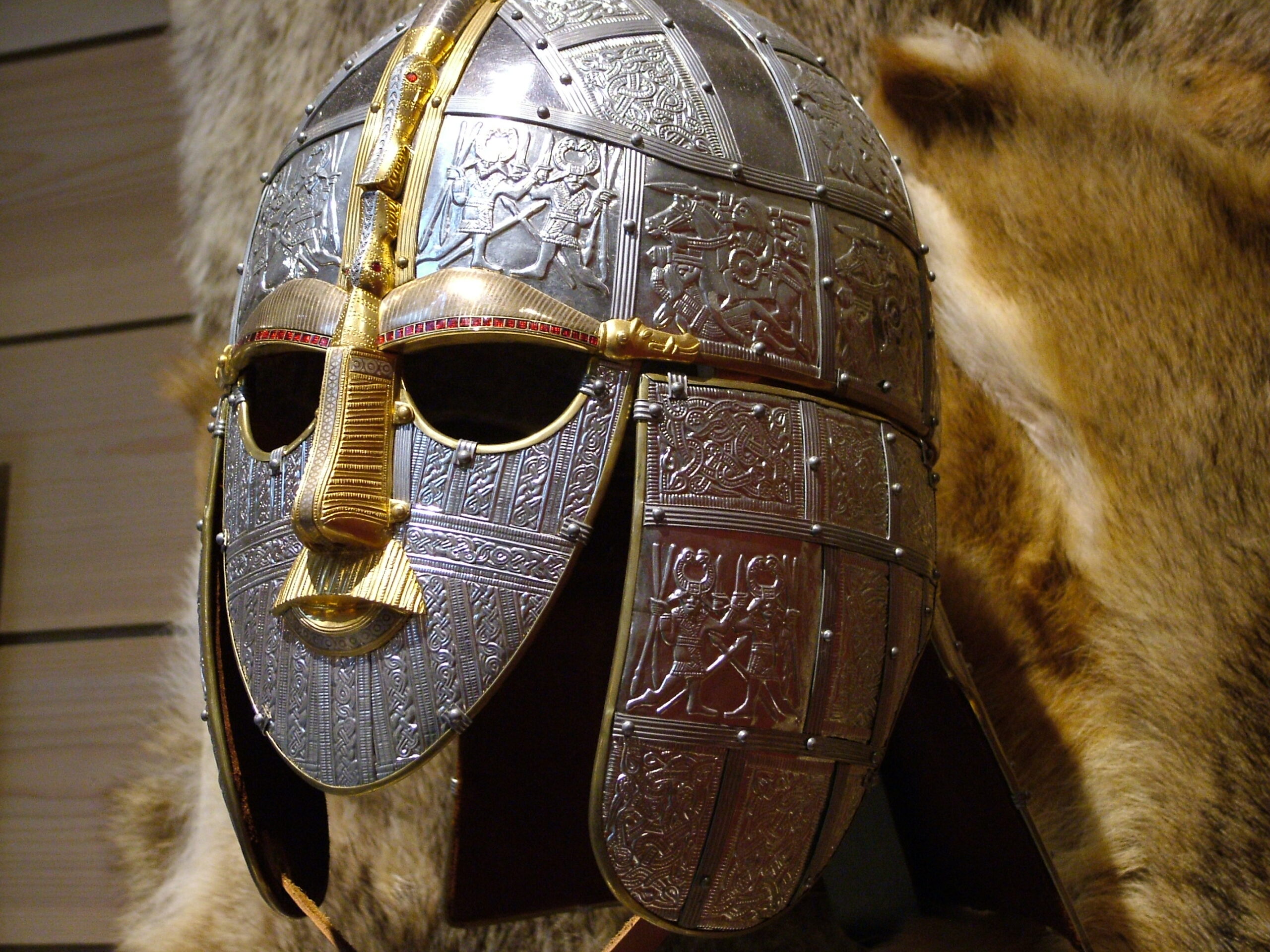
Replica of the Sutton Hoo helment [By Ziko-C (Own work), CC BY-SA 3.0, https://commons.wikimedia.org/w/index.php?curid=3533575]
The 7th century was an era when the petty kingdoms of the previous two centuries began to be consolidated into larger units. The larger realms swallowed the smaller ones, although which kingdom absorbed which much depended upon the battle nous of particular kings. Northumbria had risen to prominence in the early 7th century by having as its ruler the most fearsome warrior of the time, Æthelfrith. Æthelfrith had begun the consolidation of Northumbria by killing the king of Deira and marrying his widow. The son of the late king, Edwin, fled into exile. As Æthelfrith cut a bloody swathe through the kingdoms of early medieval Britain, he always kept a weather eye on Edwin’s whereabouts. Having an exiled prince (ætheling in Old English, a man throne worthy) was a useful bargaining chip in the lethal game of thrones that united the disparate tribes of the time.
Edwin appears to have made a round of southern kingdoms, going from Mercia, the marcher kingdom in the Midlands, to the Britonnic kingdom of Gwynedd (that an Anglian prince might find refuge among the Britons might seem strange but it held with the oldest piece of realpolitik, that the enemy of my enemy is my friend), before fetching up in East Anglia in the kingdom of King Rædwald (who is likely to have been the man buried in the ship burial at Sutton Hoo).
In East Anglia, Æthelfrith had his quarry cornered and, as the most powerful king in the country, sent messengers to Rædwald requiring him to deliver up Edwin, in pieces or in person. But the obligations of hospitality laid upon the warrior caste were great. Faced with going against these principles, Rædwald chose to fight. Bede records that it was the scornful rejoinder of his wife that decided the vacillating king to chance his arms against Æthelfrith. It may also have been the realisation that giving up Edwin would explicitly announce his status as inferior to that of Æthelfrith and East Anglia was a rich and proud kingdom, relatively safe from Æthelfrith due to its distance from Northumbria.
So Rædwald and his warband, bolstered by Edwin and the men who had accompanied him into exile, decided to chance battle. They caught what seems to have been a relatively unprepared Æthelfrith on the River Idle in Nottinghamshire and there, the most feared king of his time died. It was no easy victory: Rædwald’s own son was among the dead. But in consequence, Rædwald became the most powerful, and richest, king in the land while Edwin took up the rulership of the kingdom of Northumbria.
This article first appeared in The Great Outdoors magazine. I like it and, to save it from complete obscurity, here it is for my handful of faithful blog readers. I hope you enjoy it! I’ve included some of the photos I took for the article, but my camera failed for the first walk, to the Thames marshes near Fobbing, so I’ve included a couple of Wikipedia images in its place. As a writer who takes photos for articles, my only advice is to get there early to catch the dawn light and, possible in this digital age, take hundreds of shots. Some of them will turn out all right!
In search of England’s lost wildernesses
Confession time. I love mountains, the wild high places this magazine is dedicated to, but it’s the flatlands – marshes, fens, plains, steppes – that fascinate me, exerting a sort of appalled, rubbernecking attraction. There’s something about the way I can walk for hours and then stop and look around and realise that I haven’t got anywhere; how the sun pins the walker to the ground like a sadistic lepidopterist; the way the world itself seems to roll beneath your feet as if each stride is turning the globe.
I would have chalked this all up to personal peculiarity if it had not been for a series of discoveries while writing and researching my books. It turns out that, for almost all our history, the true wildernesses of England, the places people whispered of in fire-lit tales as the refuge of monsters and the haunt of bandits, were not mountains and moors, but marshes and meres. When Alfred the Great fled Guthrum’s surprise attack on Twelfth Night, he made his way through the winter landscape to the ‘fen-fastnesses’ of Athelney, the Isle of Princes, an island surrounded by the shifting waterways of the Somerset Levels. After William the Bastard had cut down Harold at Hastings and harrowed the north, the last defiance against the Normans came out of Fenland. Smugglers and bandits, radicals and revolutionaries have all emerged from or taken refuge in England’s shifting, uncertain wildernesses, disappearing into legend among the rushes and reeds. Today, those seeking escape from civilisation and its discontents head north and west, to where the geology of Britain has largely confined our hills and mountains. But, once, wildness was wet, not high.
So, I set out to explore what remains of England’s lost wildernesses. But, first, I had to find them.
I’m a Londoner: child of immigrants, born and raised in the Great Wen. The city is a creation of the river, the ‘strong brown god … unhonoured, unpropitiated … but waiting, watching, and waiting’, and the Thames marshes were the first lost wilderness I went in search of. The Romans built their bridge at the first bridgeable point of the Thames, joining the gravel pile of Ludgate Hill to the salt marshings of Southwark. Downriver, the river carved brown channels through a flood landscape, until generations of hydro engineers forced it, sullenly, into channels. The gateway to Empire, the Thames became the busiest, richest thoroughfare on earth, a honeypot of sail and steam, with settlements perched upon high, dry ground, all the way to the sea.
The marshes of the Thames
By the village of Fobbing, near the candy-coloured delights of Canvey Island, the land steeps down to a flat, ridged plain, scored with creeks and channels; a five-thousand-acre remnant of the great Thames marshes that walked along the river to the sea. Arriving at dawn just after the longest day of the year, I was greeted with a sight that was slightly less apocalyptic than I’d hoped for. Yes, the sun in its rising stained the river a pleasing shade of crimson, but where were the columns of fire? Last time I’d been this way, the oil refineries by the river were sending up great gouts of flame from ranks of flare stacks, as if greeting the sun in kind. But today, the refineries were cold, lifeless. I learned later that they had gone into receivership; the last shut down in 2013 – apparently even oil mega corporations can go belly up.
Fifteen minutes later I was thoroughly lost. This, I decided, staring at a hugely unhelpful OS map, was ridiculous. I was only just outside the M25, smack in the middle of the most densely populated area of the most densely populated country in Europe (England having overtaken the Low Countries), and I was lost. But lost I was, and as morning mist rose up to cover my legs, and drown any appreciable landmarks in shifting grey, I caught a first, halting sense of the shifting, subtle nature of these places, which are neither land nor water, but phase from one state to the other; as shapes swirled thickly in the mist, I began to catch some of the fear that stalks the accounts of fens and marshes in English tales and legends. But then the shapes resolved into cattle, as surprised to see me as I was to see them, and the rising sun began to burn off the mist.
By Glyn Baker, CC BY-SA 2.0, https://commons.wikimedia.org/w/index.php?curid=9150043
After so long walking on level ground, the climb back up to Fobbing proved surprisingly difficult for muscles trained into the horizontal. In the village, outside the White Lion pub, I saw a sign commemorating the villagers who had risen in revolt against the imposition of a swingeing poll tax – but this revolt took place in the 1380s, not the 1980s. The people of Fobbing lit the match that set off the Peasants’ Revolt; John Ball, the hedge priest whose sermons (‘when Adam delved and Eve span, who was then the gentleman?’) on the injustices of the feudal system provided the spiritual justification for the revolt lived in Norfolk and Essex before moving to Kent; John Wrawe raised the men of Essex and stirred revolution in Cambridgeshire.
By ClemRutter – Own work, CC BY 2.5, https://commons.wikimedia.org/w/index.php?curid=2104727
As I walked the flatlands and marshlands of England, I found myself also following a trail of religious and political radicalism – it almost seemed that the flatter the landscape the more revolutionary the ideas it spawned.
The island of the marshes
There are few areas flatter than Lincolnshire. This was once the marsh kingdom of Lindsey, one of the small realms that grew up in the post-Roman splintering of Britain, a domain created by its geography for the great fenlands of Cambridgeshire formed its southern limit, and the Humber estuary its northern edge, while the rivers Witham and Trent all but cut it off from the country to the west. Lindsey, ‘the island of Lincoln’, has the cathedral as its peak, but other islands rose from the surrounding seas of marsh and reed, notably the Isle of Axholme. That was where I went next in my search for England’s lost wildernesses.
Trent, the name of one of the two great rivers that drain into the Humber Estuary, comes from the Brythonic word ‘Trisanton’, which means ‘trespasser’. A better description for the river could scarce be found, for it is a wilful, unpredictable water, forever flooding the flatlands around its mouth. The Isle of Axholme was an isolated area of raised ground above the surrounding marshland, and the site of the first great battle over the use and reclamation of fenland. In 1626, King Charles I sold Hatfield Chase, a huge area of peat bog just west of the Isle of Axholme, to a Dutch drainage engineer named Cornelius Vermuyden, who would get to keep for himself one third of the drained land. Only, the king had no authority to sign over the rights of common grazing, which local people depended upon. For where outsiders looked upon Hatfield Chase and saw it as ‘evil in winter, grievous in summer and never good’, the people who made their living around and upon the marshlands understood them well, exploiting them for lush pasture in high summer when other fields were bare, fishing and fowling, harvesting hemp for sails and rope, and cutting peat. But the marshmen were viewed with no less suspicion than their land: ‘Fenmen, disgusting representations of ignorance and indecency!’ They may not have been educated, but the people of Axholme could work out what the drainage ditches Vermuyden was digging through Hatfield Chase meant and they ‘came unto the workmen and beat and terrified them, threatening to kill them, if they would not leave their work’. The Battle for the Bogs had begun.
It continued for the best part of the next three centuries, the rich and powerful gradually nibbling away at the marshland and taking it under their control, until the original 880 square miles of marsh in the Humberhead Levels was reduced to the peat bogs of Thorne Waste and Hatfield Moor, which Fisons continued to strip mine. It was only in 2002 that the remaining peat bogs were saved.
Arriving at dawn, and pausing to take photos, a cloud of insects descended and I was immediately reminded that the first, and greatest, defender of the marsh was the mosquito and the diseases it carried. Ague – malaria – the sweating sickness of marsh and fen had done much to create the miasma of fear that surrounded England’s wildernesses – for after all, a true wilderness must have the potential to kill the visitor.
‘Beware of adders.’ The signs, helpfully posted at intervals, showed there were other possibly lethal inhabitants of the Moor. Sadly, any snake sunning itself in the early morning light heard me long before I saw it, and slid quietly away, but the birds were not nearly so bashful, serenading me throughout in the most full-throated manner I’ve heard outside a rainforest. The patchwork of ponds, bogs, lakes, woods, scrub and stripped clear peat make for as varied a series of habitats as can be found in Britain today.
It was a dislocating place, caught between different places and times, and I, more suspended than most, was held in remembrance of King Edwin of Northumbria, High King of Britain, who fought his final battle here, amid the meres. Thinking of the men slain thirteen hundred years before, I emerged on to the stripped slabs of the Moor, where the industrial scrapers of Fisons and others pared the peat from the land, leaving a landscape that’s as near to the Western Front as anything I’ve seen. Walking out into the wastes, water lying in sheet silver either side of the ridges, I was in as lonely a place as there is in England.
Perhaps the inmates of HMP Lindholme, the double wire, razor-topped fences of which run alongside the western edge of Hatfield Moor, take some solace in the grey green banks of alder and willow that wave beyond the prison’s confines. Walking the perimeter fence is a chastening experience, the metallic clangs from the prison works interpsersing with the occasional siren. But a turn into a glimpsed opening, and I was bathed in green, leaf-filtered light, the skeletal finger of a bog-drowned tree pointing from water to sky. Leaving the moor – in Old English, the word derives from ‘morass’, again showing how our wilderness derives from the wet – I returned to the Isle of Axholme and found that here too, the flatlands had produced a radical re-evaluation of society; for Epworth, a village of the Isle, was the birthplace and early home to John and Charles Wesley, the founders of Methodism. Again, the flatlands were the cradle of radicalism. What would the Fens, greatest of them all, produce?
The Great Level
Driven from Hatfield Chase, bankrupted and imprisoned, Cornelius Vermuyden bounced back. The Fens were the great prize for the land reclaimers, and Vermuyden, with his Dutch expertise, was their chosen champion. But the locals fought back, destroying sluices and breaking dams. Insurrection was in the air, and the commoners found a champion in a local farmer, a ‘Mr Cromwll of Ely’. This farmer ensured that their complaints against the commandeering of the commons was included in the Grand Remonstrance presented to King Charles I in 1641.
But in a betrayal that seems as great as the remonstrance, once the king was beheaded and the farmer had become Lord Protector, Cromwell instigated the draining of the Great Level, engaging the men of his own New Model Army to guard the work parties. Battle continued through the next two centuries, but it was a one-way process. Charles Kingsley, writing in the 19th century, remembered how ‘dark-green alders, and pale-green reeds, stretched for miles round the broad lagoon … high overhead hung, motionless, hawk beyond hawk, buzzard beyond buzzard, kite beyond kite, as far as eye could see … They are all gone now.’
The largest of all England’s wildernesses, the Great Level, which brought down a king and defied a conqueror, was finally bisected and dissected, its life-giving waters drained, in the 19th and 20th centuries. ‘Ah, well, at least … children will live and not die. For it was a hard place to live in, the old Fen.’
It’s not quite all gone. Wicken Fen is the oldest site in the care of the National Trust, some 900 acres of fen, part of which has never been drained. The Trust plans to extend this to 10,000 acres, stretching as far as Cambridge, by the end of the century. I set off to walk from Wicken to the Isle of Ely, Cromwell’s home, following the River Great Ouse. Wicken Fen is a bird watchers’ – and song listeners’ – delight; it resounded with liquid chimmers and churrs. The channels that bisect it would have been easy for the shallow-drafted vessels of the Angles, the Saxons and the Vikings to navigate, enabling them to strike inland, far from the sea.
The river ran north, between over-engineered banks, towards the distant, looming tower of Ely Cathedral. I’d been walking for a while before I realised that the Ouse ran at a higher level than the surrounding fields of carrots and cabbages; it flows between raised embankments for now but should the levee break, the flood would be catastrophic; for the peat of the levels, once drained, has shrunk, lowering the ground surface below river level, below sea level. It was with fantasies of flood running through my imagination that I arrived in Ely and plodded upwards to the exquisite cathedral – our medieval forbears knew better than us how to create an architecture that enhanced a landscape. Cromwell’s old house is now, ignominiously, a tourist office and small museum.
Returning, as twilight fell, along an almost enclosed green lane, a hunting barn owl swooping below the branches nearly flew into me and two playing hares ground to an abrupt halt before making off into the fields.
The Fen was dark when I returned. I, as do we all, enjoy the benefits of modern civilisation but listening to the creak of willow I dreamed of flood, and the return of the waters to the Great Level. In Beowulf, the great Anglo-Saxon epic, the monster Grendel stalks Hrothgar’s hall from his lair in the fens. In England’s national poem, the monster comes from the marsh. I listened, but all I heard was silence.
The writer, George Monbiot, has called for the rewilding of Britain, but he has largely confined this to the hills and jeremiads against sheep, to places far from where we live today. How much more worthwhile would it be to reclaim England’s true lost wildernesses, that mostly lie around and about our centres of population, that we might, once again, have at our doorsteps the great, stinking, shifting levels.
What would the world be, once bereft
Of wet and of wilderness? Let them be left,
O let them be left, wildness and wet;
Long live the weeds and the wilderness yet.
Yes, it’s me, speaking at Prinknash Abbey on Tuesday 25 April at 10.30am. I’m really looking forward to this as I’ll get to spend the previous day and night with the monks of the abbey before giving my talk on the Tuesday. If you’re anywhere nearby, do come along (and I’ll sign as many books as you want!).
This summer, we went to Northumberland. The past lies deep over the present there, in this land of far horizons, and over the next few weeks I’ll write a few more entries in this occasional series, the presence of the past.
For today, we’ll look at the well in Bamburgh Castle. The rock on which the presnt-day castle stands has been a stronghold for as long as men have lived in Northumberland. It’s a great lump of Whin Sill, the layer of hard dolerite that extends, mostly underground, through Durham and Northumberland. 295 million years ago, an upflow of magma from the earth’s core was diverted on its path to the surface and, instead of exploding as a volcano, slid sideways, below the surface, spreading out along the fault line between two horizontal layers of rock, rather like the jam in a sandwich. But when the magma cooled, it formed dolerite, a much harder rock than the sandstone that sandwiched it. So, as the softer rock has eroded, the hard protuberances of the Whin Sill have emerged, producing features such as Bamburgh Rock, High Force, and parts of Hadrian’s Wall.
Part of Hadrian’s Wall, riding along the Whin Sill
Bamburgh Rock, rising a couple of hundred feet above the surrounding sea and land, is an obvious watchpoint and stronghold. But it lacked one vital feature of a defensible fortress: water. If the defenders were beseiged, they would rely on stored water and catching rainfall – admittedly, not an infrequent occurrence in this part of the world, but, the world being what it is, no doubt drought would be the inevitable partner to siege.
To overcome this deficiency, the Anglo-Saxons dug a well. Through granite. Through 150 feet of granite. And the well is still there, in the lowest level of Bamburgh Castle, with nothing but a small caption to remark this extraordinary feat of Early Medieval engineering.
The well head in Bamburgh Castle
Here’s me, standing beside the well.
Writer, wondering how they did it
How on earth did they do it?
And wondering how on earth they did it
This is what the caption says:
This Anglo-Saxon well was essential for providing the castle with a reliable and clean source of water. The well is 44 metres in depth and 2 metres in diameter. There are no records about how the well was made but one thought is that fires may have been built on top of the hard whinstone. When the rock was extremely hot, cold water would have been poured onto it causing it to contract and split, making the stone easier to work. Beneath the whinstone is sandstone much softer and easier to excavate.
The sides of the well are smooth and close to the bottom there is an arched tunnel approximately 1.75 metres in height which is reached by iron rungs set into the stone work. Running at a south westerly angle it travels to shrubbery outside the castle near the existing pump house and was made in the 20th century to carry services, out of sight, up to the castle.
So, that is, maybe, how they did it. Hot rock, cold water and hard labour. And, well dug, Bamburgh became well-nigh impregnable, the stronghold which became the base for the Idings take over of the kingdom of Bernicia, the land of the high passes.
Writing, as I do, about the seventh century AD, you’d think there would be precious little left in the way of physical connections to this time. After all, the Romans built in stone and stone endures, but the Angl0-Saxons were master carpenters, rejecting stone and brick-built dwellings for great halls made of wood – and wood decays, or burns.
So, yes, there is on one level much less left from the seventh century than from the four centuries of Roman rule. However, in writing the Northumbrian Thrones, I’ve been surprised at what there is to be found: places, buildings, structures and artefacts that have survived the vicissitudes of the centuries to bring into the present the witness of the past.
Of these, the Bamburgh Sword (which I wrote about for History Today here) is possibly the most evocative. Excavated by Brian Hope-Taylor from the castle grounds in the 1960s, it was forgotten and, after Hope-Taylor’s death, was put into a skip when his home was emptied – it was only the quick thinking of some pHD students that saved it. The Bamburgh Sword was forged in the seventh century of six strands of pattern-welded iron, making it possibly the finest weapon ever made, well, anywhere. It was wielded, in battle and rite, for three centuries before, finally, it broke and the shards were interred in the grounds of the stronghold it had helped to protect. Such an extraordinary weapon was fit for a king – given where it was buried and when it was forged, the extraordinary possibility arises that the Bamburgh Sword was the very weapon wielded by Oswald, the Lamnguin, the White Hand, the king who returned from over the sea.
After centuries under ground, the blade itself is a corroded shadow of its once self but it is on display in the Archaeology Room in the castle. This is what it looks like now (in the hands of Graeme Young, co-director of the Bamburgh Research Project):
And this is a newly forged reconstruction of what the sword would have looked like when it was wielded in defence of the kingdom of Northumbria:
Far away from Bamburgh, on the isle of Anglesey, is another, much-less known, connection with the seventh century. Back then, the kingdom of Gwynedd was the proudest and strongest of the kingdoms of the Britons that continued to resist the slow conquest of Britain by the Angles and the Saxons. The kings of Gwynedd had their fortresses and strongholds in the mountains of Snowdonia, but the ancient island over the Menai Strait served both as the breadbasket for the kingdom and its political centre, with the royal court based in what is now the small village of Aberffraw. Just two miles east of Aberffraw is an even smaller village, Llangadwaladr, and set into the wall of the parish church is a gravestone. But not just any gravestone. This stone marked the grave of Cadfan ap Iago, king of Gwynedd and father of Cadwallon, the nemesis of Edwin of Northumbria.
Go to the quiet, serene church of St Cadwaladr and there, embedded in the far wall, is the stone. It reads, ‘Catamanus rex sapientisimus opinatisimus omnium regum’, which means, ‘King Cadfan, most wise and renowned of all kings’. This is what it looks like:
And here I am, touching this direct link to the world of seventh-century Britain, when we visited Anglesey last summer.
It is extraordinary to think that these, the sword and the gravestone, have managed to survive when so little else has. If people are interested, I’ll write about other places and things that bring the past into the present in further articles for this new series.
Fellow Darkling (an author who writes about the Dark Ages in general and the seventh century in particular) Matthew Harffy interviewed me on his blog. We both, independently, wrote about seventh century Northumbria, and then were both horrified to learn that another writer was trespassing on ‘our’ patch. Read here how we reconciled without recourse to the duelling cloak and then read Matthew’s novel, The Serpent Sword, for his take on King Edwin.