While somewhat overtaken by more recent scholarship (the book was published in 1895) The Age of the Condottieri has the great virtue of making the most confusing era in Italy’s history, when everyone fought everyone else, changing sides as they went, comprehensible. As such it’s a good starting point for anyone trying to understand the complex history of 15th and 16th century Italy.
In this history of the German occupation of the Channel Islands during World War II, Duncan Barrett takes on one of the most difficult of all literary and historical tasks: to weave a coherent and compelling narrative out of a heap of individual and unrelated stories – and he succeeds remarkably. Barrett manages to make this collection of tales a book that is almost impossible to put down, as well as a portrait of what might have happened had the rest of Britain fallen to the Nazis. It’s an excellent history but an even better story, woven from individual threads expertly interlaced. Highly recommended.
Although the concept of the warrior was glorified and held up as an ideal in the songs and stories of the scops, these keepers of the Anglo-Saxon imagination also sanitised and curated the concept of the warrior. Many of the Norse skalds were warriors, and there’s no reason to suppose that that was not true of Anglo-Saxon scops too. But we don’t find in surviving Anglo-Saxon poems anything like the unadorned battle savagery of the Iliad.
The reality was grim, dark and bloody. It was the work of the men listening to the scop’s verse, and the scops chose not to amplify that aspect of their lives. Instead, there’s an autumnal feel to Anglo-Saxon verse, a sense of the loss of things, and the long defeat.
Photo by Rachel Claire: https://www.pexels.com/photo/person-under-sky-full-of-stars-5531048/
For our ancestors living in an uncertain world, a world in which death might strike at any point, life was precious and never dull. But even so, the winter evenings were long, and dark. Writing this just after the winter solstice, the sun has set by 4 p.m. Two thirds of each day is dark. I sit in a pool of artificial light – the light sustained by an incredibly complex series of interlocking systems – and defy the night.
But without artificial light, winter nights were long indeed. The fire grumbled in the hearth, maintained throughout the winter months, banked through the night and fed into new life in the morning. To fill the dim months, tasks that might be done as much by feel as sight – tablet weaving, carving, sharpening, splicing, the thousand and more tasks necessary to sustain life when almost everything had to be made locally. And as accompaniment to these tasks, there were stories and songs.
We are a visual culture, drowning in pictures and images.
Our ancestors were aural, drunk on words and sounds. And stories.
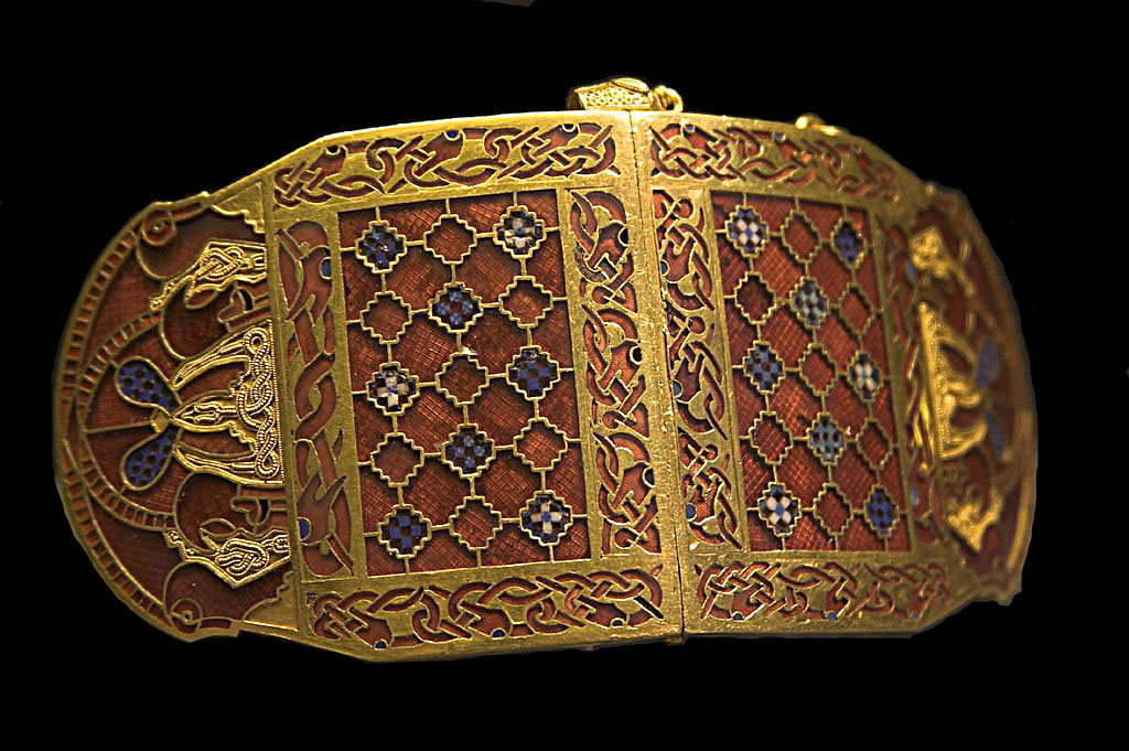
Anglo-Saxon goldsmiths created work of astonishing complexity. Looking at the finished work that survives from that time, we are left awestruck by the precision of what they did. For us, today, it’s virtually impossible to create anything similar without using magnification, but we know they did not have access to magnifying glasses.
We don’t understand how they did it. Some people have suggested the goldsmith had children doing the detailed work under his supervision, but we don’t know. It’s possible that a goldsmith taught his children how to do the work and they did it until their eyes went and younger eyes that could focus tighter had to take over, but we just don’t know.
A good friend of mine, Yossi Brain, died in an avalanche. He was climbing El Presidente, a 5,700-metre mountain in Ecuador’s Apolobamba mountain range with a climbing client, Dana Witzel, and two other climbers when an avalanche caught him and Dana. It wasn’t a big avalanche. Not one of those tides that sweep half the mountain away, just a slide of snow. In fact, it was so negligible that the other two climbers were unaffected. They scrambled over to Yossi and Dana as fast as they could but it was too late: they were both dead.
In the mountains, you can do everything right, take all the recommended precautions, and still end up dead. Just be in the wrong place at the wrong time. That was what happened to Yossi. He was in the wrong place at the wrong time.
The Silent Land is about a husband and wife who are also in the wrong place at the wrong time. Skiers, they wake for the early snow, only to be caught in an avalanche. They survive, however, but when they return to their village they find it entirely empty. There is no one there. Nor are they able to contact anyone outside. And their attempts to escape end with them circled back to where they started from.
They are good couple: Jake and Zoe love each other. In some ways, The Silent Land is a portrayal of a marriage, a marriage that works. Yes, there are the usual compromises and irritations, but it’s a marriage that is the making of both of them. And then it is tested – and found strong.
The Silent Land is a story of love, and loss, and the silence between the worlds. It’s a mystery and an unveiling and an invitation. It’s a story that stands on the borders of dream and verity, where we stand too although we think ourselves on solid ground. It’s a story that lingers long after the reading.
To make interlace jewellery, Anglo-Saxon goldsmiths ran the beaded gold wire over and under other threads of gold wire and soldering them into place as you went, creating the interlocking patterns that we see.
For the cloisonné, the goldsmith fashioned individual cells from flattened wire to accommodate each garnet and then cut and filed the garnets to shape. Once the garnets were shaped and sized, but before they were finally fitted into the design, the goldsmith backed each garnet with a layer of gold foil. The base of each garnet was indented into a shallow pyramid, and this the goldsmith fitted onto a pyramidal extrusion punched into the backing plate and foil on which the garnet would sit. So, each garnet sat upon a small golden pyramid, catching and reflecting the light and making the garnet glow a deeper red.
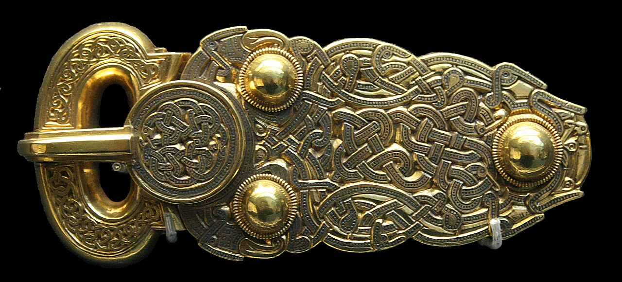
There are two main styles of Anglo-Saxon jewellery. The more gold-based one has interlacing designs of gold thread weaving over and under each other with garnets as occasional highlights. The cloisonné had a largely garnet design set into thin gold fixtures with a gold surround of interlace.
To create the piece, the goldsmith took the gold thread and laid it out on the backing. With the richest jewellery this was gold; less expensive items had a silver or base metal base. Once the goldsmith had twisted the wire into place, making either interlay or cloisonné cases, he soldered it into place. The soldering iron that early medieval goldsmiths used was a red-hot, pointed iron poker. It was heated in the fire to get to temperature and then applied to the gold where it met the base plate. Gold has a high melting point: 1,064 degrees centigrade. But the point application of a red-hot soldering iron to very thin pieces of gold will raise the temperature of the gold to melting quickly – and removing the soldering iron allows the heat to dissipate just as quickly, setting the soldered joint into place.
In principle, this sounds simple enough, and it is. It’s the application that makes it difficult, particularly when you see the delicacy of some of the work these goldsmiths did.
Much of the gold that went into Anglo-Saxon jewellery such as the Sutton Hoo buckle was recycled Roman gold, taken from Roman coinage. Rome still had prestige and a nimbus of power that was reflected in the use of old Roman gold as the basis for the jewellery of kings.
The prestige of Roman gold was greatly enhanced in the seventh and eighth centuries by the conversion of the Anglo-Saxons to Christianity. Rome was both the name of the giants who had made the still hugely impressive ruins that covered the landscape and the present residence of the Pope, God’s representative on Earth, who had, in the person of Gregory the Great, personally sponsored the mission to the Anglo-Saxons. The pilgrim path to Rome was well trodden by Anglo-Saxons from their conversion onwards, beginning with the extraordinarily well-travelled Benedict Biscop – who made five trips to Rome – and continuing throughout the Anglo-Saxon period, culminating in the two trips Alfred the Great made to Rome when still a child.
Of course, few Anglo-Saxons had the resources or time to make the pilgrimage but the fact that Rome existed, suspended in imagination somewhere between reality and Eden, added lustre and gravitas to the remembered Rome while surrounding papal Rome with the nimbus of Empire.
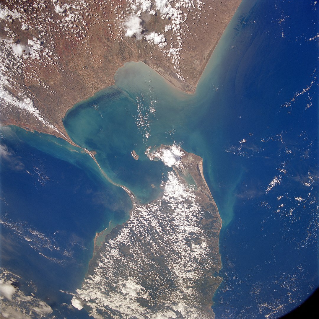
Adam’s Bridge, or Rama Setu, is a long chain of low-lying shoals and reefs connecting a spur from Sri Lanka’s north-east coast to the long ribbon of Dhanushkodi beach running south-west from Pamban Island into the ocean, pointing its long finger to Sri Lanka.
It’s a haunting place to visit. In places the spit of land is so narrow that the houses that remain have the Indian Ocean across their front gardens and the Bay of Bengal lapping against their back gardens. There was a town on the spit of land, reachable by railway. But on the night of 22/23 December 1964, a tropical storm intensified to a cyclone and hit Dhanushkodi town, killing 1,700 people there as well as the 115 passengers aboard the Pamban-Dhanushkodi train that was only a few hundred yards short of its terminus when the storm wave struck, washing the train away. The town was abandoned after the storm and remains uninhabited and largely submerged today.
Trade links between Sri Lanka and India go back to antiquity. Garnets from the island were traded up the west coast of India to the trade ports and held there, waiting for the merchants who sailed over the sea to arrive in the summer, carried by the monsoon winds. The merchants sold their own goods, bought garnets and other commodities, particularly spices, from India and returned with the autumn trade winds.
Having crossed the Indian Ocean, it was a relatively quick passage up the Red Sea before unloading and making the short crossing to Alexandria, where the garnets were sold on to merchants eager to take them further west and north until, finally, the bag of red garnets took ship again, crossing the rough waters of the outer ocean to reach Britain.